
Chump Change
SUPPORTER
The Florida Adventure Trail is on Youtube...lots of videos, check it out.
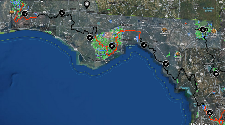
The FAT is at least 3 sections, the SOFAT or Southern Florida Adventure Trail, the FAT which tends to be the middle of the state, and the PHAT, or Pan Handle Adventure Trail.
I am in the early stages of planning a primitive camping trip this February beginning on the FAT in the central part of the state around Lake Placid, and finishing up on the PHAT, or Pan Handle Adventure Trail. I typically primitive camp out of a kayak, but high clearance campers can dip into and out of the trail or hotels can be found at points along the way for those who want or need more comfort.
The goal of the ride is for relatively stock Jeeps to be able to enjoy it, avoiding deep water crossings or mud holes, yet adding a few challenges along the way.
If you've traveled the FAT, please add to the discussion. I asked Gemini to assist, and below are the turn-by-turn directions which have yet to be validated, carefully mapped, and refined.
Gemini query and output:
"plot the actual road names, distances, and turn by turn directions on google maps for the best path on a map for the florida adventure trail for jeeps that starts roughly in the lake placid area, includes reliable primitive or tent camping, does have some off road challenges, does not require deep water swamp crossings where getting stuck in mud is very possible, includes the scenic big bend jeep trails, and ends up in the panhandle"
To navigate the Florida Adventure Trail (FAT) for Jeeps—stretching north from the Lake Placid / Highlands Hammock area up through the Big Bend Coast and into the Florida Panhandle—it is critical to plan a route that captures the best off-road challenges while bypassing deep-water mud traps (such as the swampy marl pits of Big Cypress or deep waterholes in Tate’s Hell).
Below is the 4-segment overland route with road names, turn-by-turn driving directions, section distances, off-road features, and primitive camping options. Some of the segment distances are pushing it for a day journey, and as the planning evolves will be divided into manageable distances to leave time for camp setup and breakdown.
Overview Map & Total Distance
Total Estimated Distance: ~520 – 580 miles (depending on forest side-trail detours)
Overall Path: Lake Placid / Sebring → Ocala National Forest → Gulf Coast / Big Bend Coastal Forests → Apalachicola National Forest & Panhandle.
Segment 1: Lake Placid & Central Highlands to Ocala National Forest (~165 miles)
Terrain & Off-Road Level: Easy-to-moderate firm sand roads, rolling pine ridge trails, and hardpack forest roads.
Turn-by-Turn Directions & Road Names
Start near Lake Placid, FL: Head north on US-27 N toward Sebring.
Turn right onto CR-634 (Hammock Rd) for a scenic loop past Highlands Hammock.
Rejoin US-27 N through Frostproof and Avon Park.
Merge onto FL-60 E briefly toward Kissimmee River, then turn north onto US-98 N / US-27 N toward Clermont/Ocala.
In Ocala, take FL-40 E into the heart of the Ocala National Forest.
Turn onto Forest Road 11 (FR-11) or FR-13 to enter the dirt and sand network.
Primitive & Tent Camping
Davenport Landing Campground (Ocala NF): Primitive, quiet tent sites right on the Ocklawaha River.
Hopkins Prairie / Dispersed Camping: Off FR-11 or FR-88 (pack-in / pack-out).
Segment 2: Ocala NF to Big Bend Coast & Forest Network (~140 miles)
Terrain & Off-Road Level: Deep dry sand tracks, forest fire lines, and limestone/shell gravel roads.
Bypass Warning: Avoid the low marsh trail dips near Orange Lake after heavy rains.
Turn-by-Turn Directions & Road Names
From FR-11 in Ocala NF, head northwest along Forest Road 88 (FR-88) toward Salt Springs.
Exit forest via FL-316 W crossing the Ocklawaha River bridge.
Turn right onto US-301 N toward Waldo / Starke.
Turn left onto FL-100 W / CR-18 W toward Lake City.
Take US-27 W west through Perry, FL entering the Big Bend Region.
Turn left onto CR-361 (Coastal Highway / Tide Swamp Rd) into the Goethe State Forest and Lower Suwannee Wildlife Refuge access tracks.
Primitive & Tent Camping
Tide Swamp Unit / Steinhatchee Area: Coastal primitive sites near the mouth of the Steinhatchee River.
Goethe State Forest (Tidewater Campground): Shaded primitive tent sites surrounded by pine flatwoods.
Segment 3: Scenic Big Bend Jeep Trails to Aucilla River (~90 miles)
Terrain & Off-Road Level: Moderate challenges with rocky limestone bedrock outcroppings, narrow coastal forest tracks, and pine palmetto flatwoods.
( Florida Trail Association)
Mud/Water Risk Mitigation: Stick to established forest roads (e.g., Grade 1 and Grade 5) in Aucilla WMA. Do not attempt unmaintained swamp cuts branching directly toward tidal marshes where deep mud can submerge axles.
Turn-by-Turn Directions & Road Names
From Perry, take US-98 W west along the Big Bend Scenic Byway.
Turn south onto CR-361 (Keaton Beach Rd) and connect to forest dirt grades parallel to the coast.
Continue on CR-361 across the Econfina River area.
Turn right onto Cabbage Grove Grade (Aucilla Wildlife Management Area).
Follow Cabbage Grove Rd and Econfina Grade along the rocky limestone banks of the Aucilla Sinks.
Continue west across US-319 N toward Newport/St. Marks.
Primitive & Tent Camping
Goose Pasture Campground (Aucilla River): Excellent primitive tent camping right on the dark-water Aucilla River.
Pinhook River Primitive Sites: Quiet, secluded backcountry spots off US-98 / St. Marks area.
( Florida Trail Association)
Segment 4: St. Marks through Apalachicola NF into the Panhandle (~135 miles)
Terrain & Off-Road Level: Moderate off-road driving featuring high sand ridges, pine savannahs, and narrow single-vehicle trails.
Mud/Water Risk Mitigation: In Tate's Hell State Forest, stick to main forestry roads (e.g., Corbitt Grade, Driveway Grade). Avoid the infamous "Dwarf Cypress Swamp" side-trails where water depth can easily exceed 3 feet.
Turn-by-Turn Directions & Road Names
From St. Marks, head west on US-98 W across the Ochlockonee River.
Turn north onto FR-313 or FR-321 into Apalachicola National Forest.
Follow Forest Road 321 (FR-321) west to FR-329 and FR-368 (Trout Pond / Lost Creek area).
Cross FL-65 and take FR-111 (Lighthouse Road area) west toward the river basin.
Cross the Apalachicola River on FL-20 W near Blountstown to enter the Panhandle.
Follow FL-20 W to CR-279 or Pine Log State Forest dirt roads near Econfina Creek.
Primitive & Tent Camping
Porter Lake Campground (Apalachicola NF): Scenic primitive campsites along the Ochlockonee River floodplain.
Wright Lake Recreation Area: Tent camping with fire rings nestled in longleaf pine forests.
Pine Log State Forest Primitive Campsites: Creek-side tent sites in Florida’s oldest state forest.
Vehicle & Safety Checklist for this Route
Tires: A set of All-Terrain (A/T) or Mud-Terrain (M/T) tires aired down to 18–22 PSI for traction on soft sand and slippery limestone beds.
Navigation: Download offline GPX maps (e.g., via Gaia GPS, OnX Offroad, or Avenza) as cellular service is weak in Big Bend and Apalachicola NF.
Sunshine State Adventure Co.
Recovery Gear: Bring traction boards (e.g., MaxTrax), a snatch strap, and a shovel to handle deep dry sand.
Water Crossings Rule: Before crossing any forest puddles or dips along the Big Bend coastal forests, probe the depth with a stick to verify it has a firm limestone/sand bottom rather than soft marl mud.
The FAT is at least 3 sections, the SOFAT or Southern Florida Adventure Trail, the FAT which tends to be the middle of the state, and the PHAT, or Pan Handle Adventure Trail.
I am in the early stages of planning a primitive camping trip this February beginning on the FAT in the central part of the state around Lake Placid, and finishing up on the PHAT, or Pan Handle Adventure Trail. I typically primitive camp out of a kayak, but high clearance campers can dip into and out of the trail or hotels can be found at points along the way for those who want or need more comfort.
The goal of the ride is for relatively stock Jeeps to be able to enjoy it, avoiding deep water crossings or mud holes, yet adding a few challenges along the way.
If you've traveled the FAT, please add to the discussion. I asked Gemini to assist, and below are the turn-by-turn directions which have yet to be validated, carefully mapped, and refined.
Gemini query and output:
"plot the actual road names, distances, and turn by turn directions on google maps for the best path on a map for the florida adventure trail for jeeps that starts roughly in the lake placid area, includes reliable primitive or tent camping, does have some off road challenges, does not require deep water swamp crossings where getting stuck in mud is very possible, includes the scenic big bend jeep trails, and ends up in the panhandle"
To navigate the Florida Adventure Trail (FAT) for Jeeps—stretching north from the Lake Placid / Highlands Hammock area up through the Big Bend Coast and into the Florida Panhandle—it is critical to plan a route that captures the best off-road challenges while bypassing deep-water mud traps (such as the swampy marl pits of Big Cypress or deep waterholes in Tate’s Hell).
Below is the 4-segment overland route with road names, turn-by-turn driving directions, section distances, off-road features, and primitive camping options. Some of the segment distances are pushing it for a day journey, and as the planning evolves will be divided into manageable distances to leave time for camp setup and breakdown.
Overview Map & Total Distance
Total Estimated Distance: ~520 – 580 miles (depending on forest side-trail detours)
Overall Path: Lake Placid / Sebring → Ocala National Forest → Gulf Coast / Big Bend Coastal Forests → Apalachicola National Forest & Panhandle.
Segment 1: Lake Placid & Central Highlands to Ocala National Forest (~165 miles)
Terrain & Off-Road Level: Easy-to-moderate firm sand roads, rolling pine ridge trails, and hardpack forest roads.
Turn-by-Turn Directions & Road Names
Start near Lake Placid, FL: Head north on US-27 N toward Sebring.
Turn right onto CR-634 (Hammock Rd) for a scenic loop past Highlands Hammock.
Rejoin US-27 N through Frostproof and Avon Park.
Merge onto FL-60 E briefly toward Kissimmee River, then turn north onto US-98 N / US-27 N toward Clermont/Ocala.
In Ocala, take FL-40 E into the heart of the Ocala National Forest.
Turn onto Forest Road 11 (FR-11) or FR-13 to enter the dirt and sand network.
Primitive & Tent Camping
Davenport Landing Campground (Ocala NF): Primitive, quiet tent sites right on the Ocklawaha River.
Hopkins Prairie / Dispersed Camping: Off FR-11 or FR-88 (pack-in / pack-out).
Segment 2: Ocala NF to Big Bend Coast & Forest Network (~140 miles)
Terrain & Off-Road Level: Deep dry sand tracks, forest fire lines, and limestone/shell gravel roads.
Bypass Warning: Avoid the low marsh trail dips near Orange Lake after heavy rains.
Turn-by-Turn Directions & Road Names
From FR-11 in Ocala NF, head northwest along Forest Road 88 (FR-88) toward Salt Springs.
Exit forest via FL-316 W crossing the Ocklawaha River bridge.
Turn right onto US-301 N toward Waldo / Starke.
Turn left onto FL-100 W / CR-18 W toward Lake City.
Take US-27 W west through Perry, FL entering the Big Bend Region.
Turn left onto CR-361 (Coastal Highway / Tide Swamp Rd) into the Goethe State Forest and Lower Suwannee Wildlife Refuge access tracks.
Primitive & Tent Camping
Tide Swamp Unit / Steinhatchee Area: Coastal primitive sites near the mouth of the Steinhatchee River.
Goethe State Forest (Tidewater Campground): Shaded primitive tent sites surrounded by pine flatwoods.
Segment 3: Scenic Big Bend Jeep Trails to Aucilla River (~90 miles)
Terrain & Off-Road Level: Moderate challenges with rocky limestone bedrock outcroppings, narrow coastal forest tracks, and pine palmetto flatwoods.
( Florida Trail Association)
Mud/Water Risk Mitigation: Stick to established forest roads (e.g., Grade 1 and Grade 5) in Aucilla WMA. Do not attempt unmaintained swamp cuts branching directly toward tidal marshes where deep mud can submerge axles.
Turn-by-Turn Directions & Road Names
From Perry, take US-98 W west along the Big Bend Scenic Byway.
Turn south onto CR-361 (Keaton Beach Rd) and connect to forest dirt grades parallel to the coast.
Continue on CR-361 across the Econfina River area.
Turn right onto Cabbage Grove Grade (Aucilla Wildlife Management Area).
Follow Cabbage Grove Rd and Econfina Grade along the rocky limestone banks of the Aucilla Sinks.
Continue west across US-319 N toward Newport/St. Marks.
Primitive & Tent Camping
Goose Pasture Campground (Aucilla River): Excellent primitive tent camping right on the dark-water Aucilla River.
Pinhook River Primitive Sites: Quiet, secluded backcountry spots off US-98 / St. Marks area.
( Florida Trail Association)
Segment 4: St. Marks through Apalachicola NF into the Panhandle (~135 miles)
Terrain & Off-Road Level: Moderate off-road driving featuring high sand ridges, pine savannahs, and narrow single-vehicle trails.
Mud/Water Risk Mitigation: In Tate's Hell State Forest, stick to main forestry roads (e.g., Corbitt Grade, Driveway Grade). Avoid the infamous "Dwarf Cypress Swamp" side-trails where water depth can easily exceed 3 feet.
Turn-by-Turn Directions & Road Names
From St. Marks, head west on US-98 W across the Ochlockonee River.
Turn north onto FR-313 or FR-321 into Apalachicola National Forest.
Follow Forest Road 321 (FR-321) west to FR-329 and FR-368 (Trout Pond / Lost Creek area).
Cross FL-65 and take FR-111 (Lighthouse Road area) west toward the river basin.
Cross the Apalachicola River on FL-20 W near Blountstown to enter the Panhandle.
Follow FL-20 W to CR-279 or Pine Log State Forest dirt roads near Econfina Creek.
Primitive & Tent Camping
Porter Lake Campground (Apalachicola NF): Scenic primitive campsites along the Ochlockonee River floodplain.
Wright Lake Recreation Area: Tent camping with fire rings nestled in longleaf pine forests.
Pine Log State Forest Primitive Campsites: Creek-side tent sites in Florida’s oldest state forest.
Vehicle & Safety Checklist for this Route
Tires: A set of All-Terrain (A/T) or Mud-Terrain (M/T) tires aired down to 18–22 PSI for traction on soft sand and slippery limestone beds.
Navigation: Download offline GPX maps (e.g., via Gaia GPS, OnX Offroad, or Avenza) as cellular service is weak in Big Bend and Apalachicola NF.
Sunshine State Adventure Co.
Recovery Gear: Bring traction boards (e.g., MaxTrax), a snatch strap, and a shovel to handle deep dry sand.
Water Crossings Rule: Before crossing any forest puddles or dips along the Big Bend coastal forests, probe the depth with a stick to verify it has a firm limestone/sand bottom rather than soft marl mud.
Last edited: